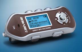
Found in the obsoleted box, a Panasonic SL–SW860 Portable CD Player SHOCK WAVE METAL S-XBS with 40 Seconds ANTI-SHOCK MEMORY 4.0 ! Nomenclature contrasts with Apple’s minimalist and elegant iPod that would debut a year after this short lived unit.
The clamshell lid was unlocked to reveal a CD rip of Lila Downs – Una Sangre (2004). You could supposedly exercise to the tunes.
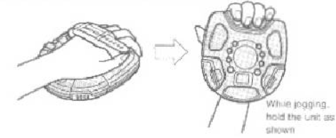
The device was designed to be clutched in hand with steadying wrist strap –awkwardly. The weight specification is 3/4 lbs. but that is understated. It feels rugged but is only water resistant (splash proof). There is an O-ring on the door so it might survive a rain shower but in fairness nothing was designed for underwater immersion. Hard to imagine jogging with this thing.
Also in the junk drawer, this iRiver iFP MP3. Using flash memory this was a popular digital audio player. Too large to slip into one’s pant pocket, it was intended to dangle from a lanyard. Still, this was an advance from the weighty CD player. The iRiver was well received despite its still unusual form factor.
These two devices, along with plenty of cassette tape players unmentioned, were exciting in concept and served needs for the moment; then came the first generation Apple. Using a a mini hard drive and at 1/2 lb. was about the size of a deck of cards — but at $399. The iPod got leaner/cheaper and we all know who won the digital player battle. Predecessors are only memories now.
Not a social position or political rant — the topic is a DIY alert system as in home security/protection.
One of the better advance alerting devices is the family dog but for redundancy, Home Assistant has an intruder notification integration, Alarmo. It provides a user interface for setting up your own alarm system completely from within the browser.
Instead of buying a dedicated siren why not use an existent sound system that is connected to your local network (LAN) e.g. bluetooth speaker, home theater, stereo. Home Assistant has an AppleTV integration for example. Your sound system can be used to deliver an .mp3 file in a tone of your choosing.
Using VLC for a media player integration: Go to Settings > Add-ons > Add-on Store. Search for and install the VLC add-on. Configure the add-on to start automatically. Next go to Settings> Integrations, look for the just installed VLC media player via Telnet add-on and click Add.
Upload an mp3 Siren File:
Download or create an mp3 file for your alarm sound (e.g., siren.mp3).
Place the file in HA’s /config/www directory (accessible via the File Editor add-on.
note that the file will be accessible via HTTP at http://<HA_IP>:8123/local/siren.mp3
Write a Script that will set the volume (between 0.0 and 1.0) and point to the sound file (your http address may differ slightly)
Go to the Alarmo tab in the Home Assistant sidebar. At the bottom is the Areas header and you should have an Area there (if not click ADD) Your Area has a link to the sensors and a link to the automations. Click the automations link. Create an automation that will run your Siren_PC script. For the Condition use the Alarm is triggered event. For the Mode choose Home or Away (optional). Task will be Siren_PC. In YAML the task looks like this:
Next click upon the RUN button under the Action header. Under Options give your automation a Name. Finally, at the very bottom click on SAVE.
Create a second automation that will run you Siren PC Stop script. In this case the event will be Alarm is disarmed and the Task entity, Siren PC Stop. Choose RUN action and give the automation a name. Click SAVE.
Try it out. Arm your system and then trigger a sensor. The mp3 file will blast away. Disarm your Alarmo system to kill the siren.
Howard Kress (1929-2001) was a dark figure in the family story as word had been passed down that there had been some sort of conflict or major falling out. The what, why, and wherefor was vague other than something about insensitivity, an insult, or spousal rivalry.
Without an accounting for the fracas between family members we can only speculate. As we know brother, sister, and mother, father never made amends as sides were drawn. The feud persisted for the remainder of their natural lives. Nephews and nieces did not reach out nor he to them out.
Howard Kress was twice married. His first wife, Essie, was well liked by family. After they divorced in 1963 the family continued their bond with Essie. Then Howard Kress married Dee Quinlan.
But this is when the blow-up happened. Possibly this was the proverbial last straw in a chain of prior resentments? Delores Quinlan was Catholic and the family she was marrying into was Jewish. Mixed marriages are common now but could this have been part of the tension?
Howard Kress was devoted and supportive of his 2nd wife. He was accepting of Dee’s faith as evidenced in an obituary published:
Howard Kress was seldom mentioned by his original family, possibly out of some regrettable moment or out of chagrin for lack of remorse or for having failed to make things right. Howard and Dee Kress lived happy full lives, in spite of the big fuss.
Customer complains that when the unit is not running a musty smell permeates the area in the vicinity of the main return air vent. The odor is strong from behind the vent filter. With the blower fan in start up, a good sneeze is a common coincidence.
The AC evaporator coil is deep within the unit and is the likely source. Continuous moisture from normal condensation drips down onto the shallow floor of the coil box compartment where it drains away by gravity. Check here first to be sure that this drain isn’t blocked. Remove the access panel for a look see.
In this situation that precursory peak revealed nothing out of the ordinary. Residual amount of collected condensate was very clean and the coil, unremarkable externally.
The other side, top, and bottom of the evaporator box is sealed and access from the ends blocked by the blower [box] unit and plenum [box] chamber.
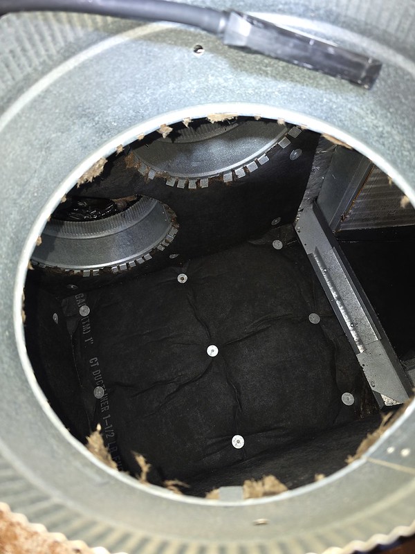
Plenum Air Box
Removing one of the [plenum] return air ducts reveals an inside look. At the top are two more return air duct ports. The box is lined with sound absorbing insulation. To the right of the image is a glimpse of the lower corner of one side of the evaporator.
This temporary access portal is just large enough to stick hand/arm into.
I angled a camera just so for the money to find a smoking gun.
insider look at the coil
The black junk found adhering can’t be good.
The coil is a heat exchanger with delicate aluminum fins doing the transfer. A combination of cleansing solution and brush work will remove the crud but care is needed. Brush strokes must be vertical (in the direction of the fins) as any lateral force will bend and deform them. If carried to the extreme they will lay down against the adjacent ones blocking their narrow air passages shut.
Note the far end. That is not an error of perspective. The two coil slabs are “V” shaped so space becomes confined and you mustn’t do damage with that brush motion.
Most people select from commercially available concentrate cleaner or you might make your own using readily available household items.
2 parts vinegar, 1 part water, 4 table spoons of liquid detergent (e.g. Dawn) for some foaming cling. Optional: a dollop of hydrogen peroxide (3% solution) to enhances antimicrobial action. Be cautious about brewing up anything toxic. For example, vinegar mixed with bleach = chlorine gas. Skull and Crossbones.
Use a pressure pump bottle with wand to spray. Let sit for 10 minutes. Brush gently. Repeat. Give that padding mat in the plenum a coating as well. Use a wet vac over the pad to remove excess. Run the HVAC (or fan only mode) to assist in the drying.
The heavy mold stuff is 20 years of neglect but hopefully the chemical will kill it. Now for the sniff test.
There are old pilots and there are bold pilots, but there are no old bold pilots
Completely my own undoing. A pleasure boat centered in the river overtook at a slow courteous pace. A risk averse person would seek to maximize distancing but with bravado I saw chance. I angled toward with the notion to get close and catch his wake. The power boat’s trailing wave has energy which, if rightly timed, imparts a forceful push forward and a free ride. Paddle furiously to match speed and experience a few seconds of surfing (in theory).
But in a cavalier half hearted effort, poorly executed; the encounter was more beam to and less quartering astern. I was out of position and [on the backside of the intended wave] over she went. The power boat accelerated away and there I was bobbing in the water. I glanced at them receding and remember actually hoping that they had not witnessed my dunking. I would have been profoundly embarrassed to have had them comeback.
The sea kayak has greyhound length for tracking and speed but lacks girth. Like a canoe or worse — very tippy. There is some natural roll resistance but care and respect is important.
*New* to the kayaking sport, I’d only viewed a self-rescue on TV but had never done one. My training exposure was 12 minutes of demonstration where a fit 20 something, YouTuber adroitly slithers back aboard.
The 90 degree flip plays in slo-mo because your brain fires a spread of thought synapses like: Oh no! and: I can’t believe this is happening! and: It IS actually happening — how ridiculous — Fool! And then you splash. There is some initial shock of going from having been in-control to out-of-whack and from dry to wet. The water is somewhat of a relief from the hot summer but immediate concern is for my $$$ phone in immersion. The kayak, with phone still secure on deck, is easily righted to dry orientation. I’m conscious of my Birkenstock $$andals dangling by big toes and fixing to float off of them as I dog paddle. I scoop them off my feet and place them into the cockpit.
With one arm draped over my craft small kicks and the other arm in a faint breast stroke I creep toward the muddy bank. The idea is to sideline out of the traffic lane and I suppose subconsciously gain shallower water. Nagging wild thought while swimming is for the attention I must be drawing. It’s a tidal river and alligator sightings within are not unusual.
The winding river is beautiful and picturesque loops back and forth on its lazy way to the coastline. It is flanked by marsh and Smooth Cordgrass. The term river is misleading as its natural flow is slow and easy. The current ebbs and flows with the lunar tide with a tide table being a necessary planning tool. The brackish water is dark reddish-brown from tannins but mostly tinted by the grey-black mud on waters edge. No light gets through to what lurks.
I take stock. Paddle has not floated off. It is tied to a safety line for such and event. Rescue gear is on forward deck under bungee cord. Tilley hat still on my head. The flotation device I’m wearing has not been inflated (CO2 rip cord) which turns out to be a good thing because any increase in bulk on my chest will interfere with the “slither” back into the cockpit.
Self Rescue
The maneuver will require the hull to be longitudinal to my heft and I will attempt to mount from astern over the transom. The first foot or two of distance is easy enough. The bow stem rises lifting up some, in pendulum (teeter- totter) as the pointy aft end sags from my weight.
Hands grasp for the cockpit coaming for grip and then with torso further along, the seat back rest or forward bracketry; whatever you can cling to. I had to improvise this part as I felt my way. What wasn’t expected was progress impeded by life jacket and wet clothing dragging across the aft deck bungee. With forethought no objects were stored there upon but everything on my chest, lanyard whistle, snaps and buckles frustratingly managed to snag into this cordage impediment. Hooked.
Extricating inch x inch and finally sprawled over cockpit center. I raised my torso to ride astride cowboy style, plunked my duffer down into the seat and swung my feet and legs aboard. Whew!
Whole again, reunited and catching breath, I reach forward to starboard to pull the bilge pump out from under the webbing on that deck. Simultaneous lean, tug to free the pump, and the water still inside sloshed its weight in unison and I flip again. Note to self: Easy does it. Be methodical, Take your time.
The hand operated plunger pump, for getting the water out, was not effective. The mechanical motion was tiresome and lengthy. Slow going. I determined in the moment that a bailing scoop or small bucket would be apropos.
Self Rescue Deux
With stamina remaining and newly found experience and having drifted all the way ashore I was ready to try again when a fellow kayaker rounded the bend and saw my plight. Offering moral support and a steadying hand on my bow I climbed back in again as before. Great success.
Instead of going solo it is a commendable option to have a companion when possible to assist in time of need and to offer backup. For other times a little extra contingency planning and knowledge is requisite. A swimming pool is a could place for a first time see it for yourself.
Atlantic Coast Airlines(DH) has split from its original holding company in Fresno and from the route map archived below you can see that the fleet still wears the first generation UEX livery. New is the De Havilland Dash 8 and BAe Jetstream 41 to fulfill expansion opportunities afforded by marketing partner United Airlines.
Atlantic Coast Airlines Route Map – in full resolution here
In a reluctant concession the Dash-8 aircraft (and pilots) were transferred from United’s storied Air Wisconsin Airlines (DX) affiliate and with them came baggage.
Air Wisconsin another United code-share, as the story goes, had used precious CASH to acquire its fleet of British Aerospace ATPs and with an economic downturn had become strapped for operating capital. United stepped in and acquired the company. Far from being a rescue United was most keen on retaining [DX] Chicago O’Hare gates, the crown jewel. Air Wisconsin’s BAe 146-300 jet fleet was promptly spun off and the other half of that group (Dash 8 fleet) in divestiture, came to ACA.
Welcome to ACA. Disgruntled and militant flight crews having felt that they’d been hosed by United were not happy to have involuntarily landed at Atlantic Coast. Nor were they well received by the original pilots at ACA as their respective seniority would be diluted. Expense to operate the Dash-8 was not a complimentary fit for the company. It could only sub a redundant mission bracket with the EMB-120 currently on property.
Seniority is everything for an airline pilot. Those higher on the list benefit from better pay and quality of life. A seniority number determines which aircraft and routes you choose to fly and whether you are a Captain or a co-pilot. This list is set in stone with a simple ranking by date of hire — unless there’s a merger/acquisition. Imagine the ensuing fairness battle that takes place when administering the combination of two lists. Hint: ain’t nobody happy
In short order ACA was upon shaky ground and was about to miss payroll. British Aerospace plc with deep pockets appeared in the hour of need. By shotgun, BAe would take both the De Havilland and Brasilia fleets in disposal trade while ACA would submit to becoming the USA launch customer for their new BAe Jetstream 4100 aircraft. The leasing and capital infusion setup was a lifeline.
The flight crews were not pleased. Blithely ignorant as to the why (it came out eventually) they considered the fleet consolidation to be a rational decision I suppose. The transition from Dash-8 and Brasilia to J41 was not perceived in best case a lateral move but rather an equipment downgrade.
Mid-Life
In 1997, a crisis of sorts: Atlantic Airlines wanted to rid itself of the unloved obsolete prop-planes to fly the latest in the new to the industry 50 passenger seat jets.
Costs spread across 19 and 29 seat aircraft were increasingly disadvantageous. Regional Jets from Bombardier and Embraer where coming online and code-share managements were convinced that passengers would adopt them and readily buy flight tickets. One problem; the pilots at United Airlines were deadest against and union contracts gave them leverage to put the brakes on. Regional pilots had zero say. The UAL pilots were (rightfully) concerned about agency and they saw these smaller jets as the proverbial camel’s nose under the tent. Eventually concessions would take place but even so it wasn’t cart blanche for the regional partners.
Eager with anticipation and perhaps to pressure United, ACA jumped the gun went forward anyway and placed an order for 12 jets. A green light from United was not immediate. Nevertheless delivered aircraft arrived with the early ones painted in an ACA color scheme – not United’s — in a statement that ACA was determined to operate the planes regardless.
The original White fuselages had dk. blue underbelly. Clever really, all they had to do was respray the top half.
The new jets were not sidelined for long. With alleviated discord, these aircraft were repainted with the United Express logo and everyone carried on. Everybody was upbeat. At the end of the day Atlantic Coast Airlines would operate 87 RJs, an all jet fleet system wide.
But in hindsight; Oh the passengers… These small jets too were seen as cramped and uncomfortable. Like the propeller driven craft that they replaced they were only tolerated, just. Most preferred flying the mainline jets.
Final Hours
Following the September 11 attack and economic downturn UAL was facing financial struggles. All of ACA income was dependent upon the health and welfare of its parent but there wasn’t much hand-wringing circa 2002 about United’s fate. Everyone understood the bankruptcy process to be requisite formality from which United would emerge whole. In fact, when the ACA team confidently went forth to renegotiate their revenue agreement they fully anticipated to be handed a better deal i.e. with more mainline flying route discards.
Regional carriers operate under capacity purchase agreements, where United paid fixed and performance-based fees and covered costs like fuel and landing fees, while managing sales pricing, revenue, and loyalty programs.
This did not happen. United bluntly dashed their high hopes and sent them home for reflection. United wasn’t doing direct negotiations. It was turned over to a faceless 3rd party hired solely to cut costs to the bone. Fees being paid to regional feeders would be severely curtailed.
With diligence ACA leadership came to the realization (they said) that United’s new deal would bleed out company profits and lead to ruin. There was an alternative — Divorce. Management’s thinly disguised ambitions eluded to in the 1997 deployment of the CRJ program was a clue. With bravado and audacity they believed they could go it alone. ACA amassed their multi year profits into a war chest which they would deploy against their former partner. They believed that as a discount airline they could compete on United’s turf.
Such a plan would be a risky venture. Privately, the rank and file felt such a dissolution to be a suicide move. But on many high hopes a plan was hatched. Atlantic Coast Airline dba United Express bet the farm gave notice. The 15 year partnership legacy and logo would be cast away and the company re-invented and rebranded, fittingly, as Independence Air.
Disclaimer
The content of this blog post reflects my personal opinions, recollections, or information gathered from publicly available sources. It is not intended to be construed as factual or definitive. Any references to historical events, individuals, or companies are presented as my own perspective and should not be taken as verified fact. Readers are encouraged to conduct their own research and form their own conclusions. The author is not responsible for any misinterpretations or consequences arising from the use of this information.
WestAir Commuter Airlines (1979) expanded rapidly to provide connecting passenger feed to United Airlines on both coasts as of the year 1991. By then WestAir Airlines dba United Express was part of parent company, WestAir Holdings, Inc.
The IAD domicile on the East coast was spun off to a newly formed company, Ed Acker‘s Atlantic Coast Airlines dba United Express. At dissolution. Employee Associates who had been domiciled on East duty were offered a one time opportunity to come home.
Those who elected to return to West Coast would be out of luck for WestAir was to become part of the ambitious Mesa Air Group before then losing their United Express contract all together. Atlantic Coast continued to prosper in the subsequent years, offering stable employment but that’s another story.
full resolution scan is here
Load factors were not sustainable, reference the ASMs in the chart. This was a good thing for the relative comfort of those onboard but unfortunate for the company’s bottom line which contrasts with the always packed flights of today.
Those were exciting times. From humble beginnings in Cessna 402’s and Britten-Norman Trislander’s primarily in California only to 37 cities in six western states and 28 cities in eleven eastern states, WestAir operated a national route system (their words).
My first smartphone was the original iPhone 2G acquired at its debut in 2007. Six or so iterations hence, but who’s counting, I have been a loyal fan of the product. Every several generations, when a replacement was called for, I couldn’t help but glance over at the competition but that is as far as it ever went. In short order my family unit was seemingly locked into the Apple ecosystem, seduced by unlimited call minutes between us or by their excellent but proprietary video calling and messaging features. To change over would have meant upheaval and never gained any traction. My interest was mostly curiosity. And now, boxed to act through bluster I’ve jumped ship.
caveat: I did have a jailbreak fling with an iPhone 3 way back when and mostly for the street cred. It was an intriguing excursion, a preview peek at what I am buying into present day.
We shall see what I’ve been missing all along and report on what has been sacrificed. It will be a learning curve to get up to speed with Android OS; I am a complete newbie. {I tried watching a ramshackle YouTube presenting Samsung Galaxy “tips and tricks” but couldn’t keep up) Apple has always provided a smooth, elegant, and dependable interface and my expectation is that I will be losing standardization for the less polished but greater freedom of configuration and personalization albeit with added complexity.
Preliminary Report
I don’t have the new hardware within my grasp as it will take a few days to arrive but that’s okay; I want to get a head start. My first question is: Does the new phone come with a charger? and no they do not, so best get that ordered straight away. I’m glad I asked because the Samsung commerce site, perhaps out of chagrin, doesn’t make it crystal that a charger nor cable is part of the package. (In fairness, Apple no longer includes them either) They do display a lengthy list of optional accessory extras which include charging solutions and you should take that as a hint.
Samsung’s Galaxy S25 can handle up to 45W for charging speed but the cable must support it. Whereas iPhone used a lightning connector cable made to Apple only specification and dead nuts simple, my new hardware uses USB-C end to end. I have one or two of these acquired over time but found out that they can differ in spec. Specifically, to take advantage of the power the cable must be rated at 5A. A 3 amp cable at 9V could only deliver 27W max. Further more some chargers having a Programmable Power Supply (PPS) or support for USB Power Delivery (PD) requiring USB 3.0 compliant cables for optimal performance.
USB cable research was required. Score one for Apple’s easy to insert plug. Apple’s smaller travel size charging brick for a gentle overnight or a larger size one for immediacy.
Apple was forced to ditch the Lightning Cable for the USB-C standard after pressure from the European Union in 2023. Maximum charging rate for iPhone is 30W currently.
Our Brody family lived in Ward 2 of Youngstown Ohio, according to the Census and the house number is 36 Hine St. The family had recently arrived from the old country and settled into this space full of hope and promise. Youngstown was an industrial powerhouse in its day.
Not the grandest of locations, there had to have been great smoke and noise pollution with the major railroad exchange and the Republic iron and Steel Company just 2 blocks over. I can’t imagine that there was any bathing in the Mahoning.
This neighborhood is long gone. In 2025 satellite imagery the transformation is evident. The mill works on river’s edge was decimated as the Great Depression precipitated a Rust Belt. Most of the train tracks and all of the row houses have returned to earth.
The 1920 Federal Census shows the Brody family moving North of it all into new surroundings: 227 Fairgreen Lane. Progression. There Arthur Brody and wife Ida shared a duplex with sister Laura Brody Harrison & Max Harrison adjacent. Anna Brody Robins & Sam Robins lived on the other side of the street (231?) and Jacob Brody & wife Jennie obliquely across at the corner. The street view in 2025 depicts an vacant lot where the house once stood. I’m sure the Brody residence was a near copy of the [green] duplex dwelling in the street view next door to the now empty lot.
Even grander, in 1928 the Arthur Brody family moved to a home of their own up on the hill by a few blocks but still near. From meager beginnings in an industrial zone to a warm happy family enclave they’ve done well.
Eventually, Youngstown, for the offspring, was but a memory as surroundings and new opportunities beckoned as we too can visually imagine some of the memory in Youngstown.
Source: Windows Letters to Ayla by Jean Zipp 2014 pg. 7-8 (Memoir)
The name is all that we had. The only intel passed down from 1st generation to the 2nd was this name and that as Fannie M’s first husband he had sired a child and then shortly thereafter became no longer relevant. The parents had divorced early without scuttlebutt.
We will never know the full back story; for everyone with firsthand knowledge has passed on. Family who with meaningful curiosity that asked about their grandfather were either stymied or didn’t press the issue. All had lived happily thereafter with an adoptive loving father/grandfather but as for Abraham Hellman we, in the moment, want to know more. Genealogically speaking, who was this man, our flesh and blood and what happened to him?
Other than his name, the spelling of which isn’t certain, we can surmise that he was of similar age and background as Fannie. Our Nannie Fann (1900-1986) immigrated from the Russian Empire at the age of 6 with her parents Hyman and Dora Morris and younger sister Rose. They settled in Pittsburgh. Hyman Morris died 3 years hence.
19 JUN 1921 Pittsburgh Press (pg. 59)
Our first recorded discovery is a marriage announcement in the society section. Although a good strong start there are vagaries with the Groom. Mr. & Mrs. H Helman of Pittsburgh doesn’t provide much of an investigative lead and Helman is a spelling variation right off the bat. Not that Hellman is a common name, it isn’t unique in the county area, but apart from the news clipping there are no Helmans (with one L) to be found… a quick end to that course of search.
Hellman, Helman, Hellmann, Helmon — the surname takes several forms. Ultimately we amateur genealogists choose the spelling from consensus of available sources and certificates.
Browsing sources for other potentially promising candidates turns up one Abraham Hellman (1898-1956) with vital statistics that fit the scenario e.g. age and locale, save for the spelling and parents, Mr & Mrs. J Hellman that are contrary to the above narrative. Is the wedding plans snippet grossly inaccurate or are we only hoping that our new Abraham find fits the puzzle. A goose chase. Without further corroborating evidence there is not a definitive connection between Fannie M and this Abraham.
The Pittsburgh Press (pg. 1) 31 JAN 1912
Here is Abraham as a lad on a city streetcar making front page story news. If this is our guy he survived the accident. No linkage here, just a remarkable story.
Follows is another published story further along:
The Pittsburgh Press (pg. 8) 9 JAN 1923
Another unfortunate happening 10 years on, Abraham Hellman and business partner Hyman Greenblatt are insolvent. Their National Grocery Company has failed — 2 years into Nannie’s marriage.
Sadly for family but lucky for we researchers this next bit is discovered. A Deed transfer in the borough of Coraopolis Lot No. 115 in a subdivision and within the same month’s timeframe. It’s clear that the business partners have raised funds to pay creditors.
Allegheny County – 22 JAN 1923
The names are telling. We have now linked Fannie M with Abraham by way of Grantors Hyman and Bessie, and Grantee, Jacob Hellman. Jacob Hellman has received their property for $1 OVC. He happens to be Abrahams father. A shared address will confirm this.
We have ordered received a copy of the original marriage certificate from public records. Depending upon the success and speed of bureaucracy we should soon confirm what we think we have discovered.
The newspaper’s wedding plans announcement has been verified to be incorrect. The surname is Hellman and not Helman. The parents name is Mr. and Mrs. J Hellman and not Mr. and Mrs. H Helman as printed, Jacob being Abraham’s father’s given name.
Abraham declared his [1921] address to be 136 Wooster St. but the [1920] census records place Abraham on 624 Washington St. (They moved) Subsequent City Directories and Census records place Jacob and Clara in that Wooster household too.
Abraham listed his Mother’s name as Ida. However, all other records only speak of Clara. Clara Hellman’s 1946 obituary calls Abraham, her son. It seems as though Chaya –> Ida was a very common name and many times Ida was dropped for a fashionable name (during peak immigration era) like Clara . Mother or Stepmother? There is more work to be done.
Abraham Hellman — ghost no longer, we have background story and previously unknown [to us] great grandparents newly discovered as well.