The Google Earth app gives an excellent [and free] view vantage that previously was only accessible to those willing to pay the expense of a chartered aircraft or helicopter equipped with cameras. The satellite photos only go back about 20 years anyhow so I was tickled to stumble upon early imagery courtesy of our local library. They have been painstakingly indexed and digitized so as to be searchable and retrievable online.
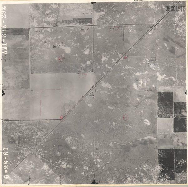
The complete photomosaic was flown by Aeroflex Corporation, Robinson Aerial Surveys Division . There aren’t many clues in this picture due to lack of identifying infrastructure back in the day, but the dark diagonal line in the center is what was then called the Coalinga-Fresno highway better known today as McMullin Grade. Madera Avenue drops straight down from Kerman to the North (center of picture) and meets an end at our diagonal. That point is a good reference as our property is directly across the highway.
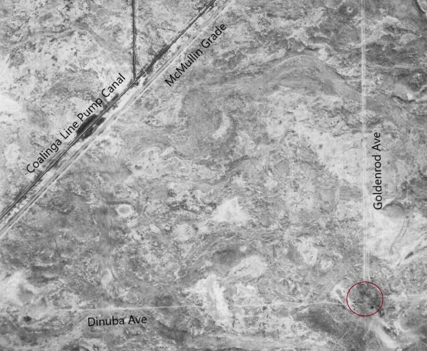
This next example, was flown by Aero Exploration Co., Tulsa, Oklahoma. Unfortunately, the corner tip of our future property (referenced above) was not part of this survey. I have labeled the marks this time so you can get your bearings. Note the red circle that I drew. This is the Southeast corner where we eventually drilled our very first deep water well. irrigation transformed the place as, you can see, this land was forsaken arid desert.
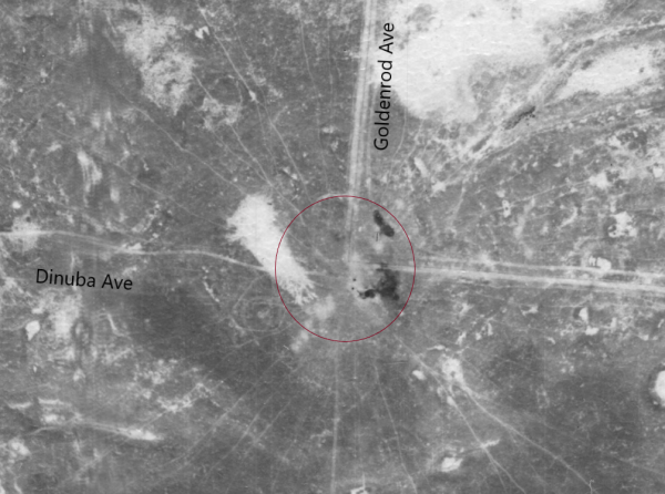
This detail clip from a very early survey again depicts the Well location and is interesting because you can observe outbound radiating lines like spokes. These would be cattle trails that culminate in this low spot where the herd would return to drinking water. Drinkable is open to interpretation. The broad brush white areas in the picture are not sky clouds but rather concentrations of alkali rendering the soil poor. Cattle grazed this fenced land as winter rains would produce grass — along with scrub and tumbleweed. Slim pickens. Dinuba Ave is dirt road even to this day but back then you might recognize that it is none too straight in line. The land, while appearing flat in this overhead was in fact uneven and this road was merely following the elevation contour.
Massive leveling machines smoothed things when we acquired and developed the property in 1961/1962. Gypsum was spread to counter the alkalinity and the soil deep ripped to break hardpan clay beneath the surface.
We are so used to what it looks like today in all its splendor. But it was a process and these remarkable records are quite a contrast.
woah! i wonder if someday it will be possible to watch a time-lapse satellite view of anywhere in the world