The last time I ran the Dripping Rock Trail the ground was bare and dry. Winter brought record snow this year which made for a picturesque scene. Evidently folks use these trails regardless of season as the path was well packed. Traction at 35 F was fair to poor especially on the steeper inclines. The park is named for the 110 foot bluff that overlooks the Olentangy River. There are more trail settings on this river downstream but the environment is decidedly urban.
This trail was once part of a rail system which ran from Durham to Duncan it is orphaned from the better know ATT and not well traveled. The trailhead sign gave pause and we did see a man walking out with rifle slung. According to this reviewer, the area is managed by NC Wildlife Resources Commission, so I guess guns are okay. Not used to taking exercise with the hunters though.
Taking in the scene at the salt marsh I read about the delicate balance of nature, the sensitive Eco system and how this wetlands was now protected and being reclaimed by plankton, fish and fowl. From the 1920’s the area had been in environmental decline; zoned for industrial and disposal usage. Just behind me was a large hump of a hill . Its sides grown over with brush and shrub. Its flat sloping shaved top green with grass now has a golf driving range park perched upon it. Who would know that until 1987 this innocent looking mountainous lump was the city landfill dump? I was pausing at the Sanchez Lagoon section of the Bayside park. The trail is parallel to its better known parent the Bay Trail which offers a cleaner view of the San Francisco Bay as opposed to the obtrusive Bayshore 101 Freeway on the other side of the mud flat. I’d not traveled it before so it was nice to cover new ground and discover the (former) identity of the area. BTW, I can recommend Gabrielle & Daniel’s (gourmet) Mexican Grill at the Golf Center; not holding its restored location against it.
The Connecticut River Walk Bikeway is a quick exit from downtown Springfield. My route terminated abruptly after 1 1/2 miles. For a longer leg go the other direction. Paved surface, scattered with downtown dwellers types.
From Old Town take a right. The bike trail follows the Sacramento River to the confluence of the American River at Discovery Park and continues for miles and miles. Sampling a small portion on foot I passed through arid land sustained by the River. There are Elder Trees, and impressive 90 foot Cottonwood Trees draped with cascading wild grape vines. Stick to the lush North side of the American River to maximize scenery and shade.
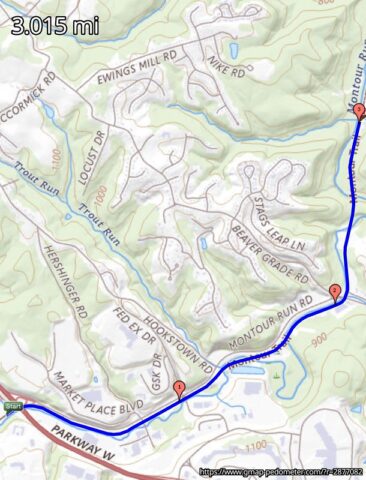
Today’s quest: The Montour Trail which follows the Montour Run beginning at the confluence of the Ohio River. I sampled a section between the 5 and 2 mile markers. The trail project is well documented with a map: here and many photos: here. It is well traveled with folks on foot and bicycle although I did see a fellow on a unicycle ?! with big rim and knobby off road tire. What next!
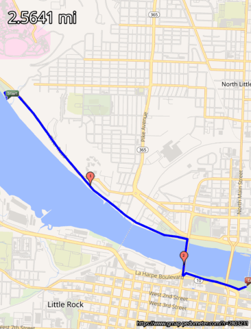
Crossing the river was the objective and the pedestrian bridge project spied almost two years ago is STILL unfinished. In fact much of the River Trail, hailed as complete, — isn’t. But it is possible to navigate via the River Rd. and due to the Arkansas River being in flood stage this day, staying high and dry was the only option. Paved greenway. [Gmaps Pedometer]
Last visited this site 2 years ago and at last got the chance to return and explore this very scenic but unfinished trail to rails system.
The Bermuda Railway is an interesting history story. It was the most expensive (cost per mile) track system in the world. As many track sections were constructed on trestle bridges over bays and over rocky shoreline much is missing today. Detour excursions on narrow paved roads are necessary for these areas. These streets are not for the faint of heart. They lack sidewalks in many places and one must thread between traffic and knee high stone retaining barriers. Be prepared to jump and straddle these walls should rather large muni buses and even an occasional semi squeeze close. Traffic does let up some following rush hour. Finally, all vehicles are right hand drive and therefore on the “wrong” side of the road. Being on foot you have to anticipate how the cars are going to come at you. The actual trail route segments from Bailey’s Bay to Shelley Bay are positioned next to the sea with unobstructed views of the North Atlantic. There are not any dull moments. Bring camera for captures like this one, this one, and also this one. Crushed rock and grass at 2.8 miles.
38F with face stinging ice pellets but otherwise periods of sunshine and wind my Gortex and fleece provided relative comfort as I tackled The Greenbelt Forest Preserve. Smooth running on wide hard pack crushed rock trail loops. There is a claim that this natural habitat of Oak trees and swamp was farmed at one time by decedents of freed slaves. Also that Green Bay Road, which splits the preserve, sits atop the mid-continental divide. There would appear to be some history to the place. Had a stare down encounter with this handsome creature otherwise I had the place to myself. I would imagine that the area is quite picturesque during the green season.


