Category Archives: jogging

LAX layover

Lots of fashion on the Strand. Come to stroll, strut and be seen. I believe that most of them arrived on retro-schwinn bicycles. Pro beach society types have the practiced style and look of year-round weekend beach time. Manhattan Beach, CA is “Was up!” compared to Venice Beach – “Ich don’t think so“. Google Earth Placemark

A good lunch location is the El Sombrero #1, for authentic Mexican food. Bueno.
Seattle Edgewater

The Seattle Elliott Bay Trail runs along natural edgewater. I picked up the trail at the NCL pier and reversed course at the top of Smith Cove Waterway (2.25 mi). The course is paved and wide enough for bicycles and bladers.

Google Earth placemark

LAX layover

From Aviation and Century we climbed on the Big Blue Bus #3 and rode Lincoln St for 20 minutes. At Ocean Park Blvd. we jumped off and headed west on foot for a little over a 1/2 mile. We stumbled upon a local farmers market already in progress and had fun tasting the fresh fruit samples. Onward a few more blocks to the beach. North or South take your pick. Jogging, biking, roller blading, walking, people watching. No thongs or string bikinis. I guess that’s only Hollywood stuff. The Venice Beach / Santa Monica Ocean Walk is a bit seedy. The hippie jewelry, incense and tarot card vendors look like refugees from Nor Cal, immigrating by way of Big Sur no doubt. I half way expected to see Fletch bumming about 🙂

Google Earth Placemark

San Diego

Go left. Find famous Balboa Park. From 6th St. and Laurel St. is the Cabrillo Bridge. Stay on the grass and keep it to your side as you traverse downhill, through the Dogs and Owners Off Leash romp area. Discover a park utility road which crosses under the bridge for a nice jog route. The park is 1400 acres and I presumed that there was more than botanical gardens and old museums. Google searches turned up tease phrases like Old Bridal Trail and Florida Canyon but the route that I describe is not well marked and certainly not advertised. Local knowledge only and this is the way to see San Diego in the wild. The majority of this run parallels the old Cabrillo Highway [163] so the natural aspect is spoiled somewhat by the dull roar and din of traffic. I did cross many trail forks leading through ravines filled with flowers and Coastal Sage Scrub. ( One such diversion led me to a shanty, and not wishing to intrude, a quick 180. If the well-to-do dwellers on the rim above only knew… )

Google Earth Placemark

SFO layover

Big city nature.

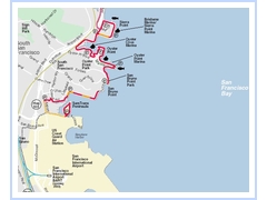
Fabulous jog this morning on the San Francisco Bay Trail, next to my layover digs…
Oyster Cove (north of SFO) is representative of the clean view.

Google Earth Placeholder

Portland, ME

great running route on the Back Cove. Fresh sea air and sights and smells from the tidal marsh.

Portland, ME

great running route B

Portland, ME

great running route A

Tampa layover

Safety Dinning. Settling in to a booth for a late-lunchearly-supper at the P.F. Changs I decided on Kung Pao. Chad, the waiter, makes note of my choice and then asks: any dietary requirements or allergy concerns ? [blink] Maybe Chad is gun shy? Another patron didn’t survive his meal? We live in a litigious society and must sign a release acknowledging that the coffee is really hot? Naw says I. Jazz it up. I take full responsibility for myself. and Chad dispatches my order to the kitchen. Perplexed from this interview , I realize that it’s the PEANUTS (listed in the menu description, although, a fine print disclaimer on the menu might have been more PC) Ah so! But I have an iron stomach. Those slippery buggers are a challenge with the chop sticks though. You have to position them from 12 O clock high otherwise they squirt away. Hard to nab one at a time.

Google Earth Placemark

trail

The Washington and Old Dominion right of way is 100 feet by 45 miles. The trains stopped in 1968. Virginia Power strung towers and transmission lines while the NVRPA built the greenway. The length is paved for cyclists and a parallel utility road of crushed rock and sand serves as a bridle access. I used the dirt path for my exercise as it offers more cush, and to avoid mixing it up with the fast 2 wheeled traffic. Starting from mile marker 21 I followed this route to the Sully Rd. overpass just short of marker 24 before doubling back.

Google Earth Placemark