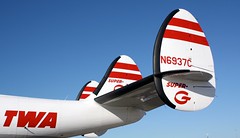
 This old goose, like most old transport – locomotives, ships, airliners, has led a colorful and checkered existence. There are glory days in the beginning followed by declining efficiency, revenue and rising competition from newer more advanced innovation. This Lockheed 1049 Constellation was conceived toward the end of the second world war and for its day was the fastest and best of its size and class. Unfortunately, its brethren were immediately conscripted for military usage and they did not see civilian service until later in the ’50s – just in time for the beginning of the jet age. These piston engined planes, as technologically evolved as they could be, were soon eclipsed by new jets. The Constellations, though glorious looking, were handed down to second tier, 3rd world, and freight companies. Eventually they wear out from use, abuse, lack of proper care due to high cost and inadequate budgets. They sit unused or mothballed waiting for buyer or scrap heap or in lucky cases: rescue. Such was the career of N6937C, which I was able to photograph at an airshow display at Kansas City Downtown Airport. SAC, the Save a Connie organization has nicely preserved this one.
- was a White Tail at the Lockheed factory in Burbank, CA due to cancelled order
- To Slick Airways 1959
- To Airlift International 1966
- To Bal Trade1968
- grounded in Miami, FL and seized by airport for non-payment of fees 1970
- To Aircraft Airframe Inc 1971
- Leased to Vortex Inc 1972
- Leased to Sky Trucks International 1972
- To Aircraft Specialties Inc 1973
- Converted to a crop sprayer at Mesa, AZ
- retired in Mesa, AZ from 1975
N6937C [ reference ]


